【自動重建3D模型】3DF Zephyr 4.513 根據照片或視訊自動重建3D模型
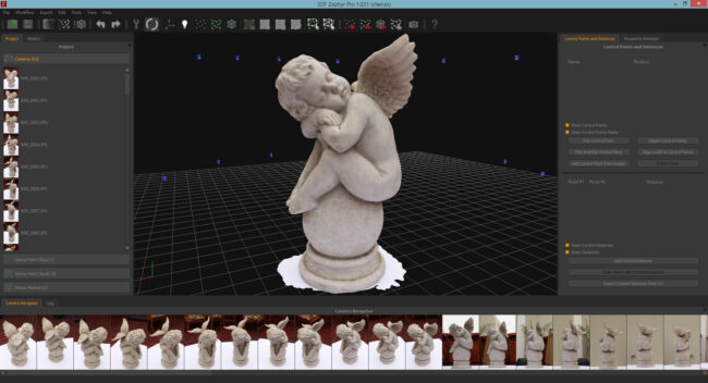
3DF Zephyr是由意大利3DFLOW開發的具有簡單操作和強大功能的照片/視訊到3D模型攝影測量軟體。它建立在3DFLOW專有的尖端重建技術之上,可讓使用者從照片或視訊中自動輕鬆地重建3D模型。
到目前為止,它擁有市場上最準確,最自動和最佳設計的Multiview-Stero算法。
3DF Zephyr提供了一個使用者友好的介面,可以匯出點雲和網格作為許多常見的3D檔案格式,並且能夠生成高解析度視訊而無需外部工具。
作為從現實中建模的理想工具之一,3DF Zephyr能夠使用照片積極地重建3D模型。
整個過程是完全主動和自動的,不需要編碼,手動修改或特殊裝置。
此外,它還可以生成真實的正字圖,數字高程模型(DEM),甚至可以計算截面,輪廓,角度,面積和體積。
想要將照片或視訊轉換為3D模型嗎?
因此,請嘗試3Dflow的3DF Zephyr,它被認為是從現實建模的理想工具之一。
BTW,3DF Zephyr航空版主要用於航空攝影測量,城市和環境監測以及地形和大地測量,精密農業等領域。
【自動重建3D模型】3DF Zephyr 4.513 主要特徵:
運動的自動結構
全局和增量管道
最簡單的相機校準管理
隨時加入照片
密集雲生成
用預設重建
進階設定
自訂設定
網格紋理
多紋理和UDIM
編輯工具
濾網,孔填充和光一致性
選取時進行網格過濾
多層支援
直接上傳Sketchfab
視訊製作和智慧快照
直接上傳YouTube
掩蓋功能
圖片匯入
影片匯入
CUDA計算
出口
本機雷射掃瞄支援
圖片和質量評估
完整的360°相機支援
比賽觀看者
外部UV貼圖
多ICP註冊
工作區合併
批次處理
固定鑽機支援
自動旗標檢驗
點雲/網格匯入
統計分析和報告
控制點,測量和體積
體積投影
空心體積計算
在一般網格上投影
點雲比較工具
輪廓造型
正射與正鑲嵌
折線圖
自動折線提取
輪廓線生成
板塊/軌道板塊
DEM和多光譜檢視器
DEM配置檔
EXIF GPS坐標
GPS exif預覽
PCS地理配準支援和轉換
多光譜支援和校準
【自動重建3D模型】3DF Zephyr 4.513網址與下載:
https://www.3dflow.net/3df-zephyr-4-0-now-available/
3DF Zephyr is a photo/video to 3D model photogrammetry software with simple operation and powerful functionality, developed by 3DFLOW from Italy. It’s built on 3DFLOW’s proprietary, cutting-edge reconstruction technology, allows user to automatically and easily reconstruct 3D models from photos or videos. So far, it has owned the most accurate, automatic and best-designed Multiview-Stero algorithm on the market.
3DF Zephyr provides a user-friendly interface, can export point clouds and meshes as many common 3D file formats, and is able to generate high-resolution video without the need to external tools. As one of the ideal tools for modeling from reality, 3DF Zephyr is able to actively reconstruct 3D models using photographs. And the whole process is completely active and automatic, no coding, manual modification or special equipment is required. In addition, it can generate true orthographs, digital elevation models (DEM), and even can calculate sections, contours, angles, areas, and volumes.
Want to convert photos or videos into 3D models? So try 3Dflow’s 3DF Zephyr – which is considered as one of the perfect tools for modeling from reality. BTW, 3DF Zephyr Aerial Edition is mainly used in the fields of aerial photogrammetry, urban and environmental monitoring, as well as terrain and geodesy surveying, precision agriculture.
// Key Features //
Automatic Structure from Motion
Global and Incremental pipeline
Easiest camera calibration management
Add photos anytime
Dense cloud generation
Reconstruction with presets
Advanced settings
Custom settings
Mesh Texturing
Multi texturing & UDIM
Editing tools
Mesh filters, hole filling and photoconsistency
Mesh filtering on selection
Multiple layers support
Direct Sketchfab upload
Video making & smartsnap
Direct Youtube upload
Masking capabilities
Pictures import
Video Import
CUDA computation
Exporting
Native Laser Scan support
Pictures and quality evaluation
Full 360° cameras support
Match viewer
External UV mapping
Multi ICP registration
Workspace merge
Batch processing
Fixed rig support
Automatic marker detection
Point Cloud/Mesh import
Statistical analysis & report
Control points, measurements & volumes
Volume projection
Hollow volume computation
Project over a regular grid
Point cloud comparison tool
Shape from Silhouette
Orthophoto & Orthomosaic
Polyline drawing
Automatic polyline extraction
Contour lines generation
Sections / Track sections
DEM & multispectral viewer
DEM profile
EXIF GPS coordinates
GPS exif preview
PCS georeferencing support and conversion
Multispectral support & calibration